|
|
Post by Erkenbrand II on May 13, 2006 3:58:58 GMT -5
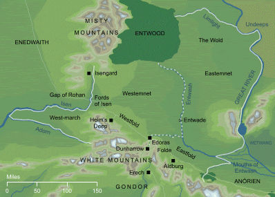
 This shows Rohan and the surrounding area. On it are marked all of the towns, cities, fortreses and regions. |
|
Eowyn
Leuthenant
   I am no man!
Posts: 84
|
Post by Eowyn on May 24, 2006 5:49:29 GMT -5
OK, to go with the map here is a brief explanation of the places of Rohan:
Eastermnet: The low-lying region of Rohan between the River Entwash and the River Anduin.
The Wold: The wide grasslands between FnagornForest and the Anduin, south othe the River Limlight. Many horses and studs are kept here.
Westemnet: The region of Rohan to the west of the River Entwash. It is divided into the Eastfold and the Westfold (Hornburg).
The Eastfold: The area of Rohan bordered by the White Mountains, the Mering Stream and the Rivers Entwash and Snowbourn. South of the Mering Stream is called the Anorien and is counted a part of Gondor. Through the Eastfold runs the main path from Edoras to Minas Tirith.
The Westfold: The region between the River Isen and the northernmost White Mountains. Here lies Helm's Deep.
|
|